
View Poll Results: I guess you can still vote if you want. Don't get too crazy though.


Multiple Choice Poll. Voters: 9. You may not vote on this poll
June Group Drive


Thread Starter
Registered User
Joined: Jan 2012
Posts: 371
Likes: 0
From: Peoria, Az
I figure our May drive was from ~9:30 to ~6:00 (8.5 hours including lunch and gas stop). Being that's basically the whole day, why not stay out of the heat for another hour or so until Phoenix has cooled down more and the sun is off us?
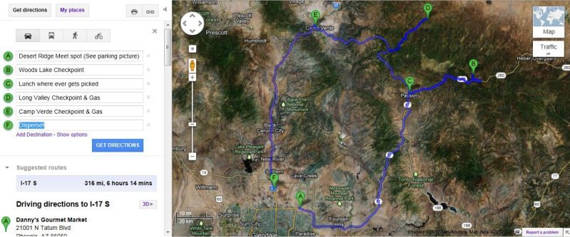
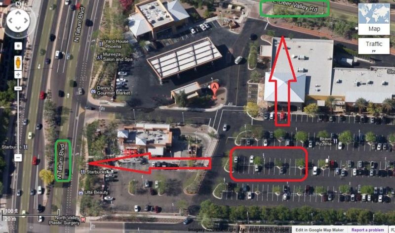
1. Meet at Desert Ridge Marketplace, Saturday 23rd, @ 9:00. Top off at station first before we leave.
Link at the bottom has complete driving directions including map. Open it, Save it, Download it, whatever you need to do. My computer doesnt have Word on it, so Il work on the template if the drive ends up enjoyable and successful.
2. Engage. 9:30. We should get to 1st stop, Woods Canyon Lake checkpoint ~12:00ish. Remember, it's hot in Phoenix, this is meant to enjoy good weather with good people, so hang out a bit. Regroup, head back to Payson for lunch.
3. Arrive in Payson ~1:15. Grab lunch at http://www.fargossteakhouse.com/ or http://www.gerardosbistro.com/. Both look good to me, up to everyone by vote. Il call either place and verify hours and such. Im guessing about an hour for lunch (inc seating, waiting, etc).
4. Next stop after lunch, heading to Long Valley Cafe/Gas. Probably get there ~3:30. Because it's a beautiful drive through the trees, why not? Easy spot to top off, turn around, come back. Long valley Cafe also makes some top notch food if your still hungry ha. 3:30 is still hot in the valley, so maybe enjoy the pines for half hour or so.
5. Last stop will be at a gas station in Camp Verde ~5:15 to do a last regroup/top off/get a drink if necessary.
6. The end of the directions is a generic spot on I17 where we will all be dispersing. So my guess is entering Phoenix around 6:30.
PLEASE comment on the plans and let me and everyone know what you think. Once again, I have not done this before, and am only guessing the times and exact ideas. Other than that, I think I'm done.
http://maps.google.com/maps?saddr=N+...t=h&mra=ls&z=9
1. Meet at Desert Ridge Marketplace, Saturday 23rd, @ 9:00. Top off at station first before we leave.
Link at the bottom has complete driving directions including map. Open it, Save it, Download it, whatever you need to do. My computer doesnt have Word on it, so Il work on the template if the drive ends up enjoyable and successful.
2. Engage. 9:30. We should get to 1st stop, Woods Canyon Lake checkpoint ~12:00ish. Remember, it's hot in Phoenix, this is meant to enjoy good weather with good people, so hang out a bit. Regroup, head back to Payson for lunch.
3. Arrive in Payson ~1:15. Grab lunch at http://www.fargossteakhouse.com/ or http://www.gerardosbistro.com/. Both look good to me, up to everyone by vote. Il call either place and verify hours and such. Im guessing about an hour for lunch (inc seating, waiting, etc).
4. Next stop after lunch, heading to Long Valley Cafe/Gas. Probably get there ~3:30. Because it's a beautiful drive through the trees, why not? Easy spot to top off, turn around, come back. Long valley Cafe also makes some top notch food if your still hungry
ha. 3:30 is still hot in the valley, so maybe enjoy the pines for half hour or so.5. Last stop will be at a gas station in Camp Verde ~5:15 to do a last regroup/top off/get a drink if necessary.
6. The end of the directions is a generic spot on I17 where we will all be dispersing. So my guess is entering Phoenix around 6:30.
PLEASE comment on the plans and let me and everyone know what you think. Once again, I have not done this before, and am only guessing the times and exact ideas. Other than that, I think I'm done.
http://maps.google.com/maps?saddr=N+...t=h&mra=ls&z=9

Moderator


Joined: Aug 2008
Posts: 9,572
Likes: 197
From: Philly Burbs
I applaud your enthusiasm. I guess its safe to say your are hooked now more than ever on the drives and the club 
Only thing I see with this drive is it is all HWY driving. No back roads, and as Roger said, quite a bit of traffic. Rt 60 to Show Low is the same route we take to get to Greer for the Devil trip. It is a very long drive, and only fun section is salt river canyon. This route also does not provide much in the way of escape from the heat. Last year on this route to Greer it was still well over 105 degrees the whole time. If you want to beat the heat, I think we are forced to head due north. My 2 cents. Dont let it discourage you though, if you and others like this idea, go for it!
Only thing I see with this drive is it is all HWY driving. No back roads, and as Roger said, quite a bit of traffic. Rt 60 to Show Low is the same route we take to get to Greer for the Devil trip. It is a very long drive, and only fun section is salt river canyon. This route also does not provide much in the way of escape from the heat. Last year on this route to Greer it was still well over 105 degrees the whole time. If you want to beat the heat, I think we are forced to head due north. My 2 cents. Dont let it discourage you though, if you and others like this idea, go for it!
Thread Starter
Registered User
Joined: Jan 2012
Posts: 371
Likes: 0
From: Peoria, Az
Roger, If you know the roads and know of any alternate routes that would be more fun/ less traffic/ whatever, bring them up. This is totally flexible since I was just tossing points on a map, It can absolutely be changed.
Ive never been to Show-low I don't think, and for our summer drives, we obviously need to get up in elevation. I just figured why not? The Full Flagstaff run, as Adam mentioned, would also be pretty sweet, keep us up in the trees for a long time as well.
It was just an idea.
Ive never been to Show-low I don't think, and for our summer drives, we obviously need to get up in elevation. I just figured why not? The Full Flagstaff run, as Adam mentioned, would also be pretty sweet, keep us up in the trees for a long time as well.
It was just an idea.
Trending Topics

Joined: Apr 2010
Posts: 3,578
Likes: 48
The drive past Payson is fairly nice. The drive from Globe back to East Valley on 60 is highway but very senic. Has some good turns and twists. Areas in the white mountains have very low speed limits and lots of police waiting to give tickets. I would like to go since I missed the May ride. I'm in for the drive and dinner sounds good.
Preference Sat. June 30th.
Preference Sat. June 30th.
Joined: Jan 2011
Posts: 148
Likes: 0
How about this route.
Go to Payson. Have lunch in Payson. I know a good American food place and an excellent family Italian place there for lunch.
Go to Strawberry.
Go past Strawberry up to the Mogollon rim. Past there somehere is the excellent vista over the rim with benches I was talking about. It's slightly off the road on the path to a lake - I just need to find it. I'm sure I can if there is interest.
Spend as much time above the rim as we want.
Back track slightly to Strawberry. Return using the other branch of 260 going down to 17 and home (or dinner).
http://maps.google.com/maps?saddr=desert+ridge+marketplace,+phoenix+AZ&da ddr=AZ-87+N%2FS+Beeline+Hwy+to:Strawberry,+AZ+to:AZ-87+N%2FCo+Rd+209+to:AZ-87+N+to:AZ-87+N%2FCo+Rd+282%2FMp+311+to:Finnie+Flat+Rd+to es ert+Ridge+Marketplace,+North+Tatum+Boulevard,+Phoe nix,+AZ&hl=en&ll=34.161818,-111.568909&spn=1.097677,1.733093&sll=33.843045,-111.74469&sspn=1.101804,1.733093&geocode=FTrZAQIdh HJT-SF1wDBf88Vhdg%3BFfj7CQIdwjdd-Q%3BFX4FDQIdnb5a-Slx2IafTkcshzFOH-ZYxF8FEA%3BFTKSDgIdRNdc-Q%3BFQQSEAIddjZf-Q%3BFU33EQIdTjRh-Q%3BFXiFDwIdZthU-Q%3BFTrZAQIdhHJT-SF1wDBf88Vhdg&oq=desert+ridge+market&t=h&mra=ls&z= 9
Go to Payson. Have lunch in Payson. I know a good American food place and an excellent family Italian place there for lunch.
Go to Strawberry.
Go past Strawberry up to the Mogollon rim. Past there somehere is the excellent vista over the rim with benches I was talking about. It's slightly off the road on the path to a lake - I just need to find it. I'm sure I can if there is interest.
Spend as much time above the rim as we want.
Back track slightly to Strawberry. Return using the other branch of 260 going down to 17 and home (or dinner).
http://maps.google.com/maps?saddr=desert+ridge+marketplace,+phoenix+AZ&da ddr=AZ-87+N%2FS+Beeline+Hwy+to:Strawberry,+AZ+to:AZ-87+N%2FCo+Rd+209+to:AZ-87+N+to:AZ-87+N%2FCo+Rd+282%2FMp+311+to:Finnie+Flat+Rd+to
es ert+Ridge+Marketplace,+North+Tatum+Boulevard,+Phoe nix,+AZ&hl=en&ll=34.161818,-111.568909&spn=1.097677,1.733093&sll=33.843045,-111.74469&sspn=1.101804,1.733093&geocode=FTrZAQIdh HJT-SF1wDBf88Vhdg%3BFfj7CQIdwjdd-Q%3BFX4FDQIdnb5a-Slx2IafTkcshzFOH-ZYxF8FEA%3BFTKSDgIdRNdc-Q%3BFQQSEAIddjZf-Q%3BFU33EQIdTjRh-Q%3BFXiFDwIdZthU-Q%3BFTrZAQIdhHJT-SF1wDBf88Vhdg&oq=desert+ridge+market&t=h&mra=ls&z= 9