
Official Itinerary - Saturday 11.th April 2009-U3


Thread Starter
Registered User
Joined: Sep 2008
Posts: 19
Likes: 0
Hi to all!!
I'm Simon and I'm helping a little bit to organize this event. In fact I've tested with Furio (Italian's President) and another italian guy the tour and I've produced some docs to explain best as possible the itinerary.
Let's start!
The itinerary on saturday 11.th April will be divided into 3 sections:
Euromeeting Tour (english version)
BTW some infos...
The first part is for me the most exiting. We will drive trought some really cool streets. From my point of view the best part of the tour is from the second half of the first section. Here we will climb the Monte Bondone - the same route used by the famous Race "Trento - Bondone": The most exciting hill-climb in europe. 17,3 km of pure racing Of course the streets are not closed for us, also be careful
  On youtube it's possible to find some cool videos!
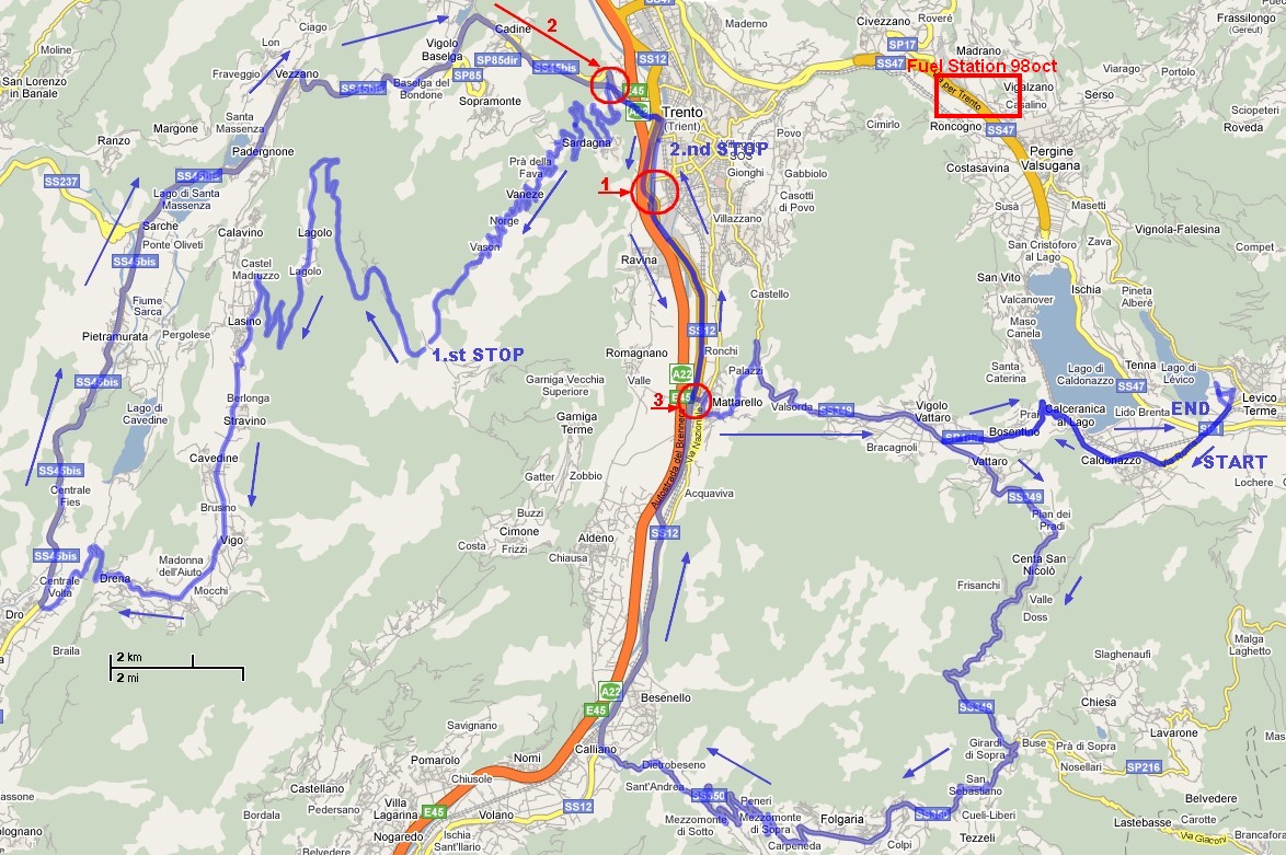
This is the map of the tour:
To help everyone enjoy the trip as much as possible, I've created some additional files to use with your GPS Navigation System. The first file is a KMZ (Google Earth) file that describe the whole tour:
Euromeeting complete Tour
As written before, the itinerary is split into 3 parts, also here the three separate KML files (Google Earth):
Euromeeting Tour - Part 1
Euromeeting Tour - Part 2
Euromeeting Tour - Part 3
(right click -> Save Target as...)
These three files are a good point of start to create itinerary files for your GPS Navigation system. There are different software like GPSBabel, ITN Converter. I've exported these files into TomTom itinerary and tested it with my car as well. They use fixed checkpoints the driver has to pass!! It's important because we are allowed by the Police to drive trought some streets only.
Euromeeting Tour on TomTom - Part 1
Euromeeting Tour on TomTom - Part 2
Euromeeting Tour on TomTom - Part 3
(right click -> Save Target as...)
Simply upload these files into ITN directory on your TomTom and load the itinerary from the software. I'll be able to load on itinerary per time. Before the start the first one, the second after the dinner and the last after the city tour.
Now some important hints:
Feel free to post your questions! I'll read this post as much as possible. I, Lee or Furio will have all answers
A special thank's to Lee helping me for the translation and some tips
Additional GPS Navigation Files will be exported from this version and released soon by me or Lee!!!
Hope to see you ASAP!!!!
Byebye!!
Simon
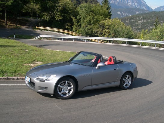
These curves are waiting you...
IMPORTANT UPDATE (3):
I'm sorry AGAIN!!! There are other troubles on the itinerary due same reasons last time. Also I've updated files above. I'ts better you download all files again, really sorry.
It's also possibile the maps we will distribute on the tour-day aren't updated, because are allready printed by a company. We will give a modified part together.
I'm sorry ... it's not up to us. Please Lee update your conversions too (AGAIN - part 1 and 3)
I've also updated the map printed showing a 98oct fuel station. Everyone will reach this fuel station on the street from Trento to Pergine/Levico on the double roadway some km before Pergine. It's an "AGIP" fuel station directly on the street at the right.
I'm Simon and I'm helping a little bit to organize this event. In fact I've tested with Furio (Italian's President) and another italian guy the tour and I've produced some docs to explain best as possible the itinerary.
Let's start!
The itinerary on saturday 11.th April will be divided into 3 sections:
- From our Hotels to Monte Bondone (Parking area Viote) - break for dinner
- From Monte Bondone to San Severino (Parking area Trento) - break to visit the city
- From Parking area on Via San Severino to Levico Terme - back to hotels
Euromeeting Tour (english version)
BTW some infos...
The first part is for me the most exiting. We will drive trought some really cool streets. From my point of view the best part of the tour is from the second half of the first section. Here we will climb the Monte Bondone - the same route used by the famous Race "Trento - Bondone": The most exciting hill-climb in europe. 17,3 km of pure racing
Of course the streets are not closed for us, also be careful On youtube it's possible to find some cool videos!This is the map of the tour:
To help everyone enjoy the trip as much as possible, I've created some additional files to use with your GPS Navigation System. The first file is a KMZ (Google Earth) file that describe the whole tour:
Euromeeting complete Tour
As written before, the itinerary is split into 3 parts, also here the three separate KML files (Google Earth):
Euromeeting Tour - Part 1
Euromeeting Tour - Part 2
Euromeeting Tour - Part 3
(right click -> Save Target as...)
These three files are a good point of start to create itinerary files for your GPS Navigation system. There are different software like GPSBabel, ITN Converter. I've exported these files into TomTom itinerary and tested it with my car as well. They use fixed checkpoints the driver has to pass!! It's important because we are allowed by the Police to drive trought some streets only.
Euromeeting Tour on TomTom - Part 1
Euromeeting Tour on TomTom - Part 2
Euromeeting Tour on TomTom - Part 3
(right click -> Save Target as...)
Simply upload these files into ITN directory on your TomTom and load the itinerary from the software. I'll be able to load on itinerary per time. Before the start the first one, the second after the dinner and the last after the city tour.
Now some important hints:
- Please ensure that you arrive on Friday night with a full tank of petrol ! We haven't time to spend saturday during the tour
- Shurely we will take a short Breefing before we start
- If all goes well you have simply to follow the car in front of you. (if the car has taken the wrong direction, ok, than that could be a problem...
 )
) - For the tour we will distribute these PDF files printed. THIS IS THE ONLY OFFICIAL VERSION OF THE TOUR. What does it means? It's possible some maps on the GPS Systems are out-of-date. We cannot guarantee all GPS Software gives the right direction, also the PDF is the official one. The GPS should only help a little bit more.
- Some streets are new. It could be possible the GPS System could not be so exact. Also take a look on the three points on the map:
- 1. -> Arrived at the half of the first part, we will enter a large street (double roadway). After 16km we have to leave it BEFORE the tunnel, exit on the right. The exit is called "Piedicastello" or "Trento Centro". If you miss this exit it's a little difficult to drive back to us.
- 2. -> Near the end of the second section, another time the street will be larger (double roadway). After 4 tunnels it's really important to stay on the right and exit on "Trento Centro". Here, like before, if you miss this exit we have to search you a while
- 3. -> In some maps the third point (and the double roadway street before) is not present. It's some years old. Also be careful follow the map and exit as descrived into the PDF.
Feel free to post your questions! I'll read this post as much as possible. I, Lee or Furio will have all answers
A special thank's to Lee helping me for the translation and some tips
Additional GPS Navigation Files will be exported from this version and released soon by me or Lee!!!
Hope to see you ASAP!!!!
Byebye!!
Simon
These curves are waiting you...
IMPORTANT UPDATE (3):
I'm sorry AGAIN!!! There are other troubles on the itinerary due same reasons last time. Also I've updated files above. I'ts better you download all files again, really sorry.
It's also possibile the maps we will distribute on the tour-day aren't updated, because are allready printed by a company. We will give a modified part together.
I'm sorry ... it's not up to us. Please Lee update your conversions too (AGAIN - part 1 and 3)
I've also updated the map printed showing a 98oct fuel station. Everyone will reach this fuel station on the street from Trento to Pergine/Levico on the double roadway some km before Pergine. It's an "AGIP" fuel station directly on the street at the right.


Trending Topics

Joined: Apr 2007
Posts: 8,905
Likes: 0
Jonny
I haven't been able to find a way to load an itinerary into a Navman
( I don't own one - just trying to read the manual )
It's easy to give you the GPS co-ordinates of each waypoint, and if you know how to load it in....
I haven't been able to find a way to load an itinerary into a Navman
( I don't own one - just trying to read the manual )
It's easy to give you the GPS co-ordinates of each waypoint, and if you know how to load it in....