Electronic Navigation at the Dragon
 05-31-2016, 05:17 PM
#1
Its never been a better time to try out electronic navigation than during this period of cheap electronics and when on a trip in a new area. If you don't have a garmin or mount for your smart phone, or just underutilized it, I highly recommend checking it out to see if its to your tastes.
Reasons its beneficial
Problems
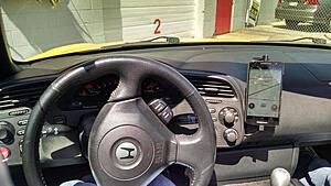
I've used traditional garmin devices and cheap Moto G android devices with great success. Now I use a large Moto X Play device with its excellent Moto Voice trigger. Even while traveling top down at 55mph, "Hey there S2K" triggers a voice prompt with ease. Power and audio connections are wired to my modifry mount so it looks very seemless. It also plays my music, triggered by Tasker. You can read more about my wiring setup in my audio/CB thread.
For group drives, I use CoPilot USA. For normal driving I use Google's driving, with maps cached as well as online when I have service. I use Tasker to heavily automate activities, so I never touch the GPS when entering and exiting the car.
If you have any questions, be sure to post up or visit me down at the Dragon!
Reasons its beneficial
- (Obviously) Never get lost: and stress less about directions and keeping with the pack. One of the major distractions when driving is worrying about navigation, and with voice directions its one more thing to keep your eyes on the road.
- Predict the road: when you are in safe areas such as straights or stops, you can check out the road ahead to know what types of curves are coming up. Instead of reacting only to what you see, you can be a bit more prepared. For an upcoming switchback, and instead of shuffling gears you can keep both hands on the wheel and watch for dangers.
- Deal with traffic: being able to see when straights (or curves) are coming up can greatly help deal with slower traffic. If you are alone it makes estimating passing zones safer, or when in a group it allows efficient accordion driving so you can still have fun while staying safe.
- Pre-program locations: having a week's itinerary at your fingertips is such a huge burden off your mind while on a trip. If using a smart phone or tablet, its simple to program date/times on your computer/laptop as entries in your electronic calendar (such as Google Calendar) which also contain addresses that will work offline. Addresses will automatically sync to your phone/tablet if you have a calendar app on your device. I have an agenda widget on my home screen with addresses for every location around Fontana, and starting navigation is simple as a couple clicks.
Problems
- Cost: some think you need a dedicated unit or subscription. Google Maps provides both downloadable maps and a "driving" feature, for free! There are many competitors that provide full downloadable maps at no cost, such as Nokia Here and CoPilot. This means any device you already own with a GPS chip (all smart phones, most tablets) will work either Android or Apple.
- Distractions: just like any tool, it can be abused. If you are not used to it, you might find it distracting. From my extensive experience, it only takes a short time to build good habits and only view your navigation when the road conditions are less dangerous. It becomes a safety tool at some point, and your passengers/followers will think you have a sixth sense about what dangers might be coming up!
I've used traditional garmin devices and cheap Moto G android devices with great success. Now I use a large Moto X Play device with its excellent Moto Voice trigger. Even while traveling top down at 55mph, "Hey there S2K" triggers a voice prompt with ease. Power and audio connections are wired to my modifry mount so it looks very seemless. It also plays my music, triggered by Tasker. You can read more about my wiring setup in my audio/CB thread.
For group drives, I use CoPilot USA. For normal driving I use Google's driving, with maps cached as well as online when I have service. I use Tasker to heavily automate activities, so I never touch the GPS when entering and exiting the car.
If you have any questions, be sure to post up or visit me down at the Dragon!


 05-31-2016, 05:32 PM
#2
The only thing important to post / add is how to deal with signal loss. Most of us already use Waze / Google Maps for cops and road directions. However the best roads often are inherently in a secluded area where even Verizon doesn't reach.
05-31-2016, 06:17 PM
#3
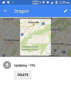
That's part of my post and I included a screenshot of offline downloading of the area near the Dragon.
05-31-2016, 06:59 PM
#5
Community Organizer


Join Date: Nov 2010
Location: Somewhere in the Sun Belt
Posts: 4,054
Received 204 Likes
on
162 Posts
 05-31-2016, 07:10 PM
#6

Originally Posted by Lovetodrive2000' timestamp='1464748736' post='23981468
Aaron... you are such a geek! 
You will have to fill me in with how to use all this!
You will have to fill me in with how to use all this!
I don't have to be nice to Aaron, he is OKI!!!!!
I treat all of the locals the same!

Also,.... his GPS will probably yell at him to turn in 22 feet! Who can miss that turn!

And we will be somewhere back in the pack reminding him of the turn in 22 feet!
Now... if you want to argue these points... get your sorry a*s up to Fontana this w/e!! and bring the Queen!!!!
05-31-2016, 07:11 PM
#7
Originally Posted by Lovetodrive2000' timestamp='1464748736' post='23981468
Aaron... you are such a geek!
You will have to fill me in with how to use all this!
You will have to fill me in with how to use all this!

Trending Topics
05-31-2016, 07:43 PM
#8
First LTD2000 you should be much nicer to Aaron. Second I would like to know how he can watch the GPS and drive those roads in the mountains. Hell I would like to look around but can't because the roads turn so freaking fast. JM2C guys enjoy the event. Almost decided to go up but things didn't work out. So jelly guy
And you don't watch the GPS while going through curves, just the straights or other safe areas.

 06-01-2016, 04:28 AM
#10

Aaron - what flavor of the CoPilot app are you using? I know you are on Android, but the iPhone App Store has about 8 different flavors of the app. Some are pricey ($19.99) and some are free. just want tot have the right app for the drive.