
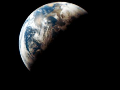
Earth photo from space (awesome!)

Registered User

Joined: Oct 2000
Posts: 15,323
Likes: 28
From: Longmont, CO
It's beautiful, but it's photoshopped.
Here's another picture of sunset from space, this time from the International Space Station:

You must keep in mind that at sunset, the portion of the Earth's surface in transition is parallel to the sun's rays. Therefore, you won't see a sharp cutoff like the above picture, as if the Earth's getting shaded by something. Rather, you'll see long, long shadows from elevation changes, gradual light intensity fades, and the like.
Another picture from Nasa's site:
And from Apollo 8:

Those real pictures also give you a good idea of just how much cloud cover there is over the globe.
From Skylab, the clouds near New Zealand at sunset:

The mountains of Big Bend National Park in SW Texas, my most favorite place in the world:

From the Space Shuttle Atlantis:

Hurricane Michelle from the International Space Station:

Here's the link if the above doesn't show up:
http://community.webshots.com/image2/5/10/...11QQwzyr_ph.jpg
Here's another picture of sunset from space, this time from the International Space Station:
You must keep in mind that at sunset, the portion of the Earth's surface in transition is parallel to the sun's rays. Therefore, you won't see a sharp cutoff like the above picture, as if the Earth's getting shaded by something. Rather, you'll see long, long shadows from elevation changes, gradual light intensity fades, and the like.
Another picture from Nasa's site:
And from Apollo 8:
Those real pictures also give you a good idea of just how much cloud cover there is over the globe.
From Skylab, the clouds near New Zealand at sunset:
The mountains of Big Bend National Park in SW Texas, my most favorite place in the world:
From the Space Shuttle Atlantis:
Hurricane Michelle from the International Space Station:
Here's the link if the above doesn't show up:
http://community.webshots.com/image2/5/10/...11QQwzyr_ph.jpg


Registered User
Joined: Oct 2000
Posts: 2,399
Likes: 0
From: San Jose
Old thread, but here's an explanation of the construction of the picture at the top of this thread.
http://earthobservatory.nasa.gov/Study/LivingEarth/
http://earthobservatory.nasa.gov/Study/LivingEarth/


Former Moderator
Joined: Nov 2001
Posts: 59,195
Likes: 1
From: Ventura, California, USA
WOW, I love this thread. GREAT PIC!
Here's something else cool. I don't know if it works all over the world, and I know it doesn't work in the less populated states in the US, but it works pretty well when it works. It's sattelite images of where you put in an address. If you have a place that has been around for a while it'll be there, or if you put in places you used to live.
go to Mapquest.com
on the left of the main page is find a map address.
Put in the address, when the map comes up look at the top of the map and if there is a tab that says aireal photo click it. Zoom in to the most resolution and you'll be amazed!
Raj
Former Moderator


Joined: Oct 2000
Posts: 16,175
Likes: 0
From: Erock is da shizzle
heh we give you 80% of our electricity..
I'm not sure of the exact percentage, but I recall something to the effect that 70% of Canada's population is within 200 miles of the US border..
I'm not sure of the exact percentage, but I recall something to the effect that 70% of Canada's population is within 200 miles of the US border..